|
|

|
sals’s TMA Blog |
|
Sardinia 2 trip 3
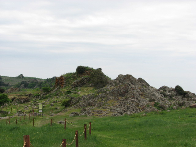
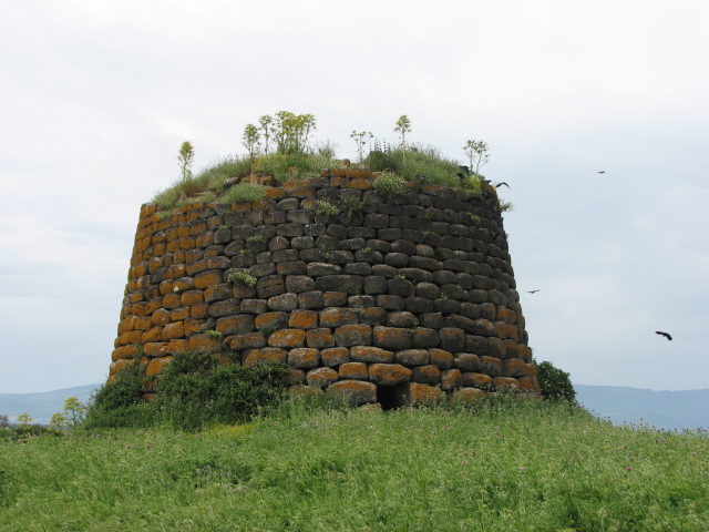
| Tuesday had been earmarked for lazing on the beach, but a grey cloudy sky meant a change of plans. The first stop of the day was relatively local, and indeed signposted from the SS131's turn to Bosa. Rather than going into Macomer (or indeed turning right to Bosa opposite Nuraghe Ruju) after turning off the main road, continue straight ahead signposted Cagliari. Under the flyover, round the bend and then a sharp right turn uphill - there's a signpost here too. Take it steady - it's mainly single track with passing places but we met a couple of large wagons coming the other way - for just over 4km, and you'll find the car park for Tamuli on the right. Tamuli — Fieldnotes18.05.08ceSignposted from nearby Macomer, this is a complex site. The grid reference given is for the car park / ticket hut; each of the main elements is being listed as a subsite. Ticket hut, tardis-style portaloo, list of prices (5 euros / 3½ euros), but no opening times and no one in sight. The posters did warn that anyone entering outside the opening times did so at their own risk and if found there, would be liable to pay the entrance fee. Fair enough! We climbed the gate and followed the track up the (gentle) hill. Tamuli — Images20.05.08ce
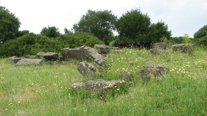
Tamuli Tomba C — Fieldnotes22.05.08ceAs you go up the hill to Tamuli, the first tomba, known as tomba C, is to the right. It's the smallest of the 3 here, and is irregular in shape. It's hard to work it out, but there is a narrow corridor, and the front of the grave has a paved forecourt but is missing the typical esedra. Remains found outside it have dated it to 1500 - 1200 BCE. Tamuli Tomba C — Images20.05.08ce
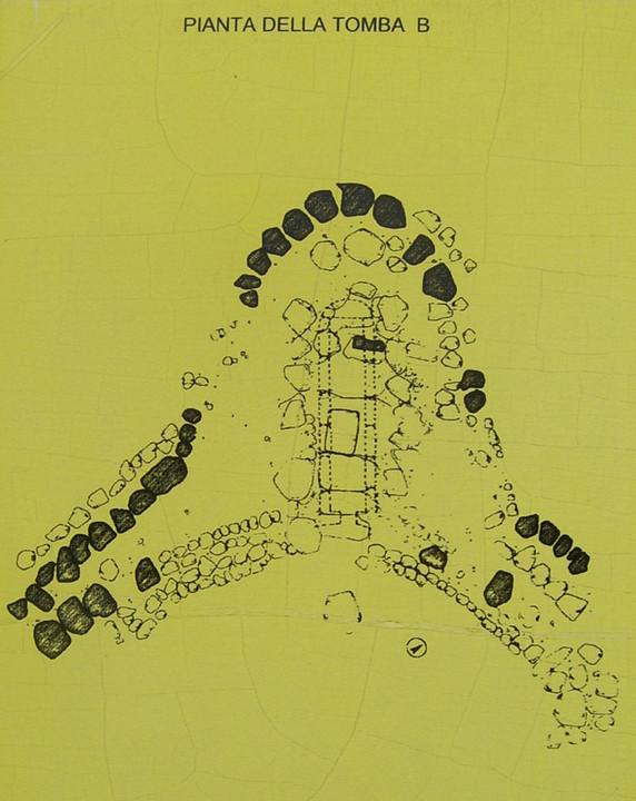
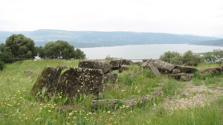
Tamuli Tomba B — Fieldnotes22.05.08ceThe second grave, tomba B, is more impressive than the first. Though ruinous, it's easy to see the esedra, or winged forecourt, with a width of 14.5m. The corridor is paved with square stone slabs. The whole tomb is almost 17½m long, and has a long low bench surrounding out. Finds from inside date it similarly to tomba C. Tamuli Tomba B — Images20.05.08ce
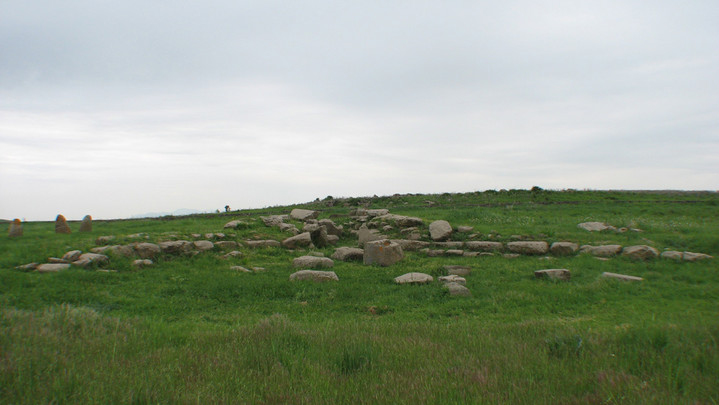
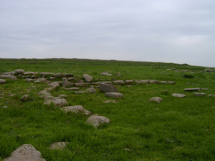
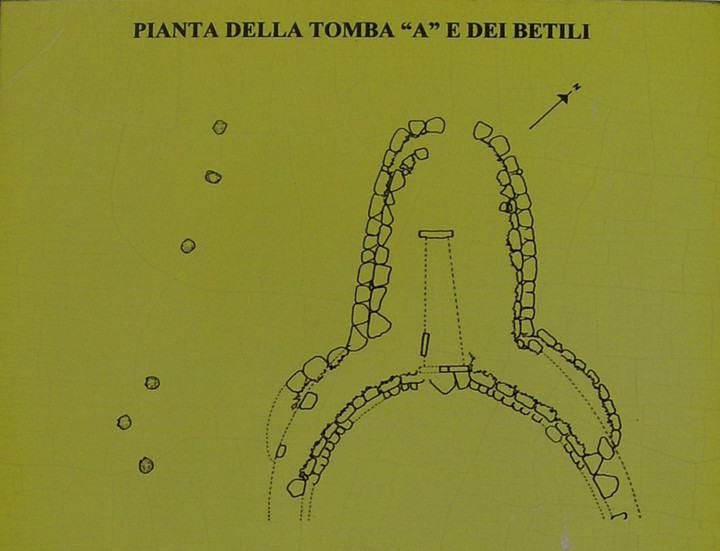
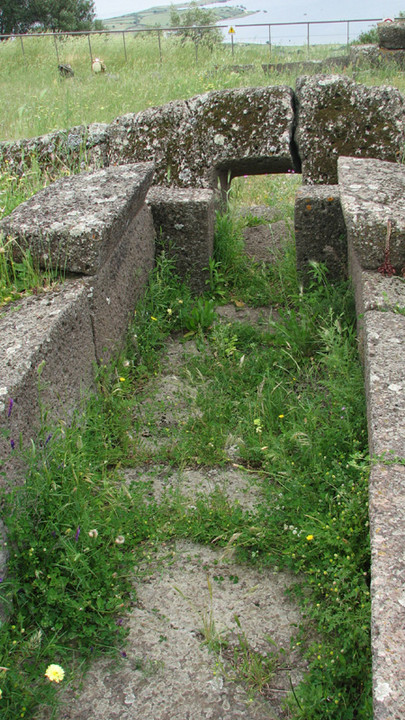
Tamuli Tomba A — Fieldnotes22.05.08ceThe largest and most impressive of the 3 tombas, also known as "Betyls' Grave" due to its proximity to the 6 menhirs (betyls or betili). As at tomba B, there's a bench along the esedra - this time its maximum width is over 20m. The total length is over 22m, and the burial corridor itself is 9.5m x 1.3m. The thick walls are actually 2 walls with the cavity between them filled with rubble and earth. The entrance to the corridor has a stone with a round cornered rectangle carved out of it - only one side remains, but it appears to be the portal to the grave. The information boards show a reconstruction - a tomba made from courses of stone as we'd seen at Mura Cuada rather than those with a stele as at Coddu Vecchju. Tamuli Tomba A — Images20.05.08ce
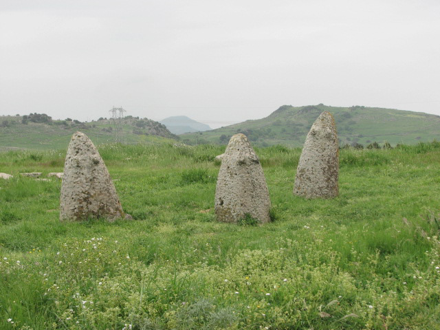
Tamuli Betili — Fieldnotes22.05.08ceRight next to Tomba A you find what's probably the most famous feature of the site - the 6 betili. They were recorded by Count Albert de la Marmora but his notes give different positions, so they may well not be in their original place. The 3 to the south represent the female figure, with obvious carved breasts; they are also taller, at just over 1.5m, than the males (1.23m - 1.38m) to the north. All are cone-shaped basalt. Tamuli Betili — Images20.05.08ce
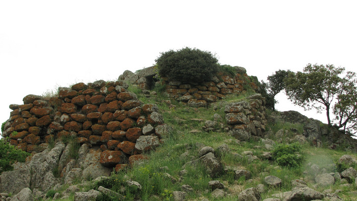
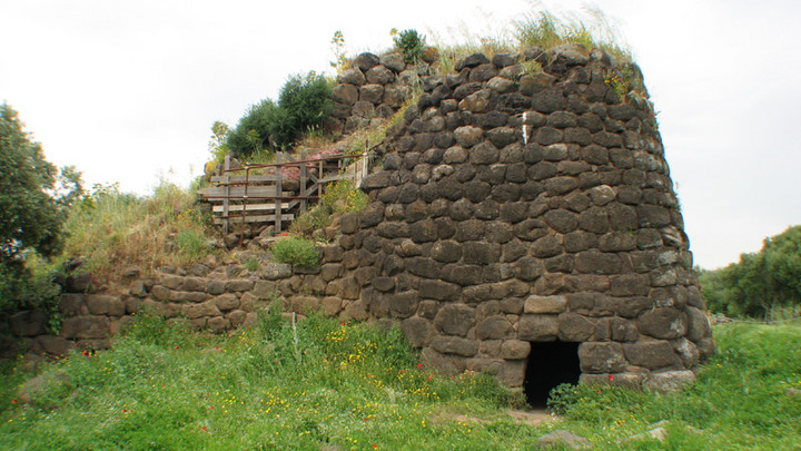
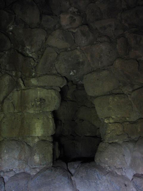
Nuraghe Tamuli — Fieldnotes30.05.08ceThe nuraghe at Tamuli is on a high point beyond the 3 tombas and the betili. It's surrounded by huts, the most impressive of these being at the end of the path beyond the nuraghe. The nuraghe itself, we were warned on the info boards, is unsafe due to landslides, and it has been roped and fenced off. Nuraghe Tamuli — Images20.05.08ce
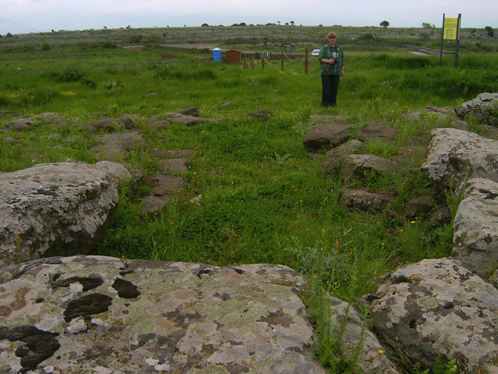
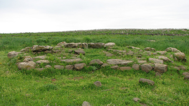
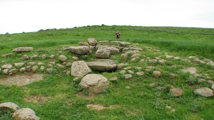
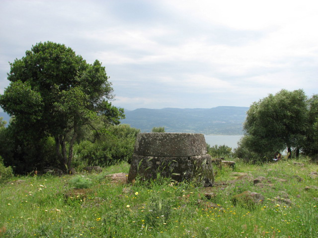
The plan for the day was tombas, tombas and more tombas. I'd a lot of research notes (as usual, Babelfished translations, so interesting reading!) on an area just the far side of Abbasanta, so we headed cross country to Sedillo. Iloi — Fieldnotes23.05.08ceThis group - consisting of 2 tomba di gigante, a nuraghe and village around it, a dolmen and a domus de janus - is just west of Sedillo, and is signposted from the town. I was rather excited about what we'd find here, and in the vicinity, and hoped that there would be someone around to ask ..... there are 3 huts which look distinctly like a visitors' centre, ticket hut, and toilets, respectively, but not a soul in sight. No notices either, but I assume an entrance fee is payable. From the parking area, the two tombs are to the south, overlooking Lake Omodeo, the nuraghe and village to the north, but the domus de janus and dolmen remain a mystery to us. My notes said that the domus de janus - Ispiluncas - consisting of 34 tombs - is "on the slopes of the hill where the nuraghe rises" and my Google Earth map showed it on the slope below the info/ticket huts. I had a grid reference for the dolmen - the wrong grid reference! - and a description of its location "the monument is found to the right of the nuraghic complex". Iloi Tomba B — Fieldnotes24.05.08ceFor the modern ticket / info huts, the first thing you see is the perfect curves of the back of tomba B - and the amazing view over Lake Omodeo. The lake however was created around 1920 with a dam across the Tirso, so the original vista would have been over the valley, with its numerous nuraghe, some of which reappear when the water level is low. The corridor is about 10m x 1.4m and is paved with huge stone slabs. The grave is impressive but not well preserved; in the small copse of trees there are several huge pieces of carved stone which once belonged to it. Iloi Tomba B — Images23.05.08ce
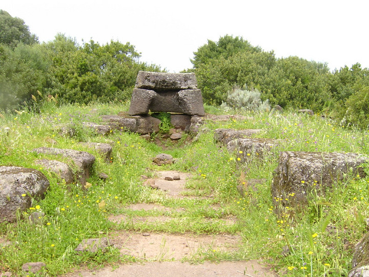
Iloi Tomba A — Fieldnotes24.05.08ceSmaller than tomba B, but better preserved, this grave is only metres away with an incredible view over the lake. The esedra is over 11m wide, and its stones are leaning forward towards the lake. The broken centre slab has a portal hatch 70cm x 55cm. The funery corridor (inside dimensions 4.7m x 0.8m) is perfectly formed and the rear of the grave has the same style of curved stones as its neighbour. Iloi Tomba A — Images23.05.08ce
 Nuraghe Iloi — Fieldnotes24.05.08ceOn the opposite side of the road is a large gate to the nuraghe and the village which surrounds it. The village huts are a more recent discovery, and the best preserved one can be seen by taking the path between the two roped off sections of village towards the trees north of the nuraghe. The nuraghe itself is of mixed type (part tholos, part corridor). Through its entrance on the south eastern side, there's a tholos chamber with an impresive niche in the facing wall. To the left, the stairs to the rest of the building have been roped off as it's unsafe due to landslides. Nuraghe Iloi — Images23.05.08ce
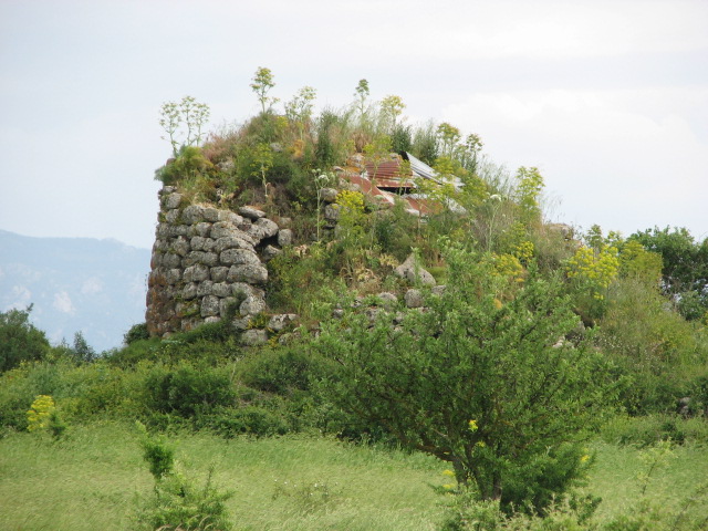
We waded through waist-high grass in search of the domus de janus and dolmen for quite a while, but eventually gave up and decided to see what we could find nearby. The next stop was Nuraghe Lighei. Nuraghe Lighei — Fieldnotes24.05.08ceAn impressive looking monotower nuraghe north west of Sedillo. It's 8.2m tall with a diameter of 14m. My research notes describe it as being constructed from red basalt; the easterly entrance has a niche to one side and steps to the left leading to the (destroyed) upper level, and leads through to a prefect tholos chamber (5.3m diameter, 7m tall) with 3 niches arranged to form a cruciform with the entrance passage. However, the field and particularly the area around the nuraghe had the largest, most brutal, thistles we'd seen so far, so we viewed from a distance but had a look around the field and the vicinity to see if we could see its associated tomba - we couldn't. Nuraghe Lighei — Images24.05.08ce
The plan was to locate the site as Santu Antinu 'E Campu - the information associated with the Sedillo area map told of 3 tombi, a nuraghe, a necropolis, a holy well, and a church. Surely not hard to find ..... but we had a dubious grid reference, a pencil mark on one of my maps with a question mark next to it, and no one in site, not even the owners of the pack (OK, there were 4 of them, but that's enough, I think!) of barking dogs, to ask for directions. So, back to the main road, round Sedillo .... ah, too far round and turn round again and try a different road. We eventually made the right choice, searching for two more tombi, a well, and two nuraghe at Busoro. Nuraghe Busoro — Images24.05.08ce
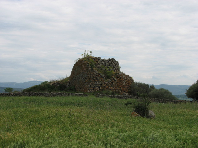
We found the nuraghe, in a field with large signs which we took to be "no trespassing", so decided to try to find something we'd seen signposted from an earlier junction - Puntanarcu holy well. We took the road from Sedillo to Noragugume, expecting the signposting to continue; several km later, we spotted a brown sign - but to Nuraghe Tolinu instead. Well, seeing as we were there ..... Nuraghe Tolinu — Fieldnotes26.05.08ceThere's an impressive high bastion wall adjoinging the nuraghe. It's very overgrown, but you can make out the upper level of the tower, and in the undergrowth, what appears to be the top of the entrance into its lower level. Nuraghe Tolinu — Images26.05.08ce
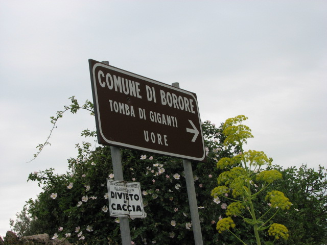
We contemplated trying to find Puntanarcu, or indeed any of the numerous sites in the vicinity, but decided to head towards home instead, vowing to come back to the area around Sedillo on a future visit, hopefully with a local expert and/or some better research notes. You could spend days here! We'd just joined the SS131 at Borore and were heading north when we spotted a brown sign ..... two minutes later we were heading south, to take the alternative route home - it's a one way sign and we'd never noticed it as we'd always been going from Macomer to Borore. Uore — Images12.05.08ce
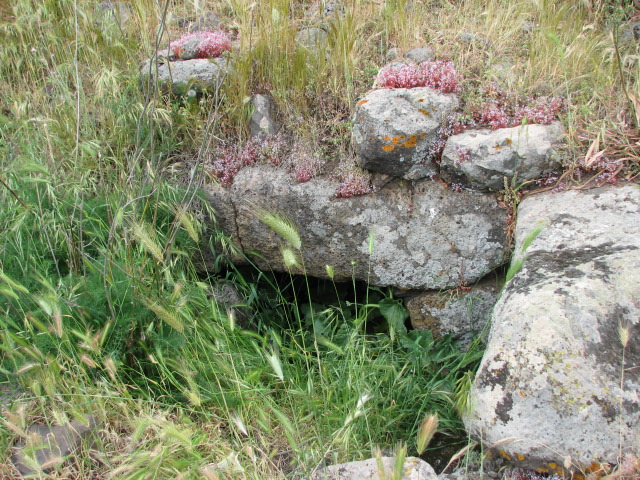
Uore — Fieldnotes26.05.08ceThere's a signpost from the main road, and then another one at a bend with a side turn only a few metres later. Then nothing. We drove on, through a flock of sheep across the road, and on, and eventually found someone to ask. He directed us back to Borore instead of his local tomba! A quick U turn, and back through the sheep again. We stopped again at the sign, and turned again, determined to find it. Back through the sheep, but this time we took a side turn to the left and parked just before the stream. The field in front of us had a rocky plateau with some ruined buildings, but not what we were looking for - so we set of up the lane on foot. Beardy went left and I went straight on, and found someone to ask. "Scusi, io non parlo Italiano. Dove è tomba di gigante Uore?" He didn't know, or I couldn't understand. So back to the car and back through the sheep. Now, turn to page 444 of your copy of TME; the middle image is Uore. Now located by the power of Wikimaps. We should have been on the other side of the road, but only metres away. Pah! Despite the day being overcast and quite gloomy, by the time we got back to our apartment and made dinner, there was a glorious sunset to watch from the terrace, glass of wine in hand. 
|
18th May 2008ce Edited 30th May 2008ce
sals's TMA Blog
Latest TMA Blog Posts
|
Comments (0) |
|
| You must be logged in to add a comment | |