|
|

|
danielspaniel’s TMA Blog |
|
Prehistoric Bike Rides 1 (Dorset - Chalbury and Came Wood)
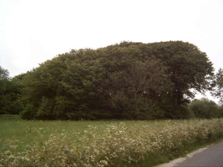
| This bike trip took about an hour and a half, and covered a distance of about 5 miles in total. I set off from my mum's house in Osmington at about 8:30am and turned right onto the A353. Nothing much of prehistoric interest in Osmington itself, although the 3ft flinty stone that stands at the village crossroads should get a mention, although I have no idea of its provenance. As I crest the Osmington Hill I get a peek of the White Horse hill figure to my right. This is a rather recent carving, and a Royalist one to boot, so I'll say no more here! Weymouth Bay spreads out to the left as I whiz down the steep hill, and as I turn the corner and come down into Preston I catch my first site of Chalbury and have to stop and take a picture. I head on through Preston, turn right at the roundabout onto the Littlemoor Road then sharp right onto Coombe Valley Road. The road climbs through the base of this valley, and large rocks are strewn about, including the intriguingly named 'Boiling Rock' (shown on 1:25000 maps) at grid ref: 694835. I reach the disused quarry and stash my bike under a dumped sofa (how quaint!) and storm Chalbury Chalbury — Fieldnotes09.06.05ceI approached this fort from the disused quarry on Coombe Valley Road to the west of the fort. Possibly not the best way as it involves scrambling up sheer cliffs and over a fence. It was obvious others had come this way though, and it did give me the feeling of being an invading Roman (which I quickly shook off, with a shudder!). If you carry on further up Coombe Valley Road there are footpaths for a gentler approach. It's a cute, roughly triangular little enclosure of about 4 hectares and was protected by a single ditch and a rampart of limestone slabs, obtained from quarry ditches inside the fort. There is an entrance on the South East side and many hut circles were discovered inside the ramparts that suggest the site was intensively occupied around 450BC. I am just going to have a peek over the western ramparts and then get back to my bike. This fort looks cool from a distance, and the view down the valley must have reminded the occupants that this was a land worth defending. There are some barrows within the ramparts also, but I know nothing about them. Chalbury — Images09.06.05ce
Back on the bike I continue the climb up Coombe Valley Road. To the SW I can see Bincombe Barrows (known locally as Bincombe Bumps). These barrows have always meant a lot to me as they were clearly visible from the house I grew up in Weymouth. I am not visiting them today, but viewing them from this new angle it is clear they were designed to make an impact from all directions. I reach the crossroads and go straight across to my next destination; Came Wood Barrow Cemetery. Came Wood — Miscellaneous09.06.05ceCame Wood is a feast of Neolithic and Bronze Age barrows of several varieties. The round barrows and long barrow south of the woods are generally on arable land and under cultivation, but in the wood itself there are 2 bell barrows, a pond barrow and a long barrow. They lie at the end of the cemetery of barrows that stretch along the South Dorset Ridgeway. It has been suggested that they formed the boundary of territory based around the major Neolithic ritual monuments of Maiden Castle, Maumbury Rings, Mount Pleasant and the destroyed Flagstones and Greyhound Yard sites in Dorchester. The two parts of this necropolis I checked out were Culliford Tree Barrow and Came Wood Bank Barrow Culliford Tree Barrow — Fieldnotes09.06.05ceThis tree covered round barrow lies between the road and the east side of Came Wood itself. (It actually lies to the West of the road, and I hadn't read Rhiannons folklore post so didn't listen for fairy music - it was too early in the day anyway!) This is an atmospheric place and I feel compelled to sit awhile and soak it up. Although I have mixed feelings about the old fashion of planting barrows and earthworks with a crown of trees, they certainly add to the sacred feel of this site, encasing me in a green chamber on this June morning. The crater in the top tells of a 'volcano' excavation; In 1858 four internments were discovered, one of which had a necklace of amber beads, two of which had gold casings. Look East and you face towards a line of 5 round barrows, with the bank barrow just beyond. Many carvings on the trees here, the earliest I can spot is 1939. Needless to say, I don't add to them! Think I'll go and have a peep through the trees at the wooded long barrow down the path to the North. Culliford Tree Barrow — Images09.06.05ce
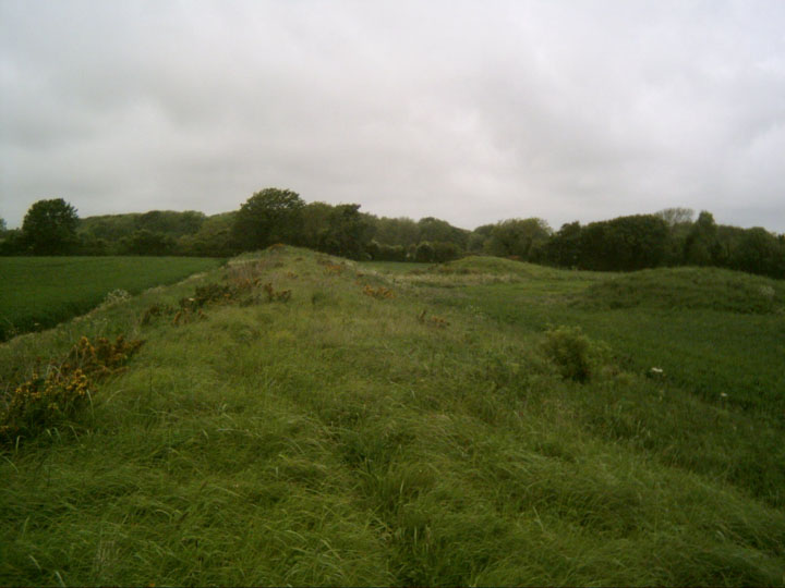
Broadmayne Bank Barrow — Fieldnotes09.06.05ceNow this is a barrow! I've just got to walk the length of this thing, and I am rewarded when I reach the other end and a deer springs out from behind one the two round barrows that sit next to each other just to the North of this incredible monument. She runs through the crops to the hedge while I stand, exalted, snapping away like a madman, trying to capture a moment I should just be in, but I suppose that is the modern condition! These 2 north flanking barrows aren't shown on the OS map, but the round barrows at both ends are. The road runs between the east end of the bank and the round barrow at that end. This is Chalky Road, which interestingly runs straight up to Broadmayne and the stones/ earthworks there. Looking around: Barrows, Barrows everywhere! An important spot, I think. Broadmayne Bank Barrow — Images09.06.05ce
I was hoping to get up to Dorchester to visit a few more sites, but it is June in the UK, and the rain drove me back to Osmington. I take the turning to Sutton Poyntz (left off the Coombe Valley Road) on the way back and get a nice look at the Eastern side of Chalbury and a breathtaking view of a definitive Dorset Valley. This route is highly recommended! |
9th June 2005ce Edited 10th June 2005ce
danielspaniel's TMA Blog
Latest TMA Blog Posts
|


Comments (0) |
|
| You must be logged in to add a comment | |