|
|

|
fitzcoraldo’s TMA Blog |
|
Tales of The Little Table -Two Freaks in a ditch.
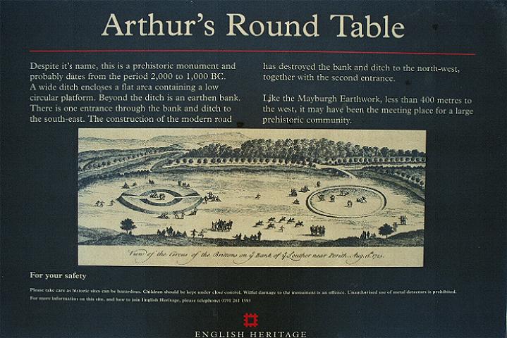
| The reports of a third henge, The Little Table, at Eamont Bridge had intrigued Stubob and me for quite a while, so we decided it had to be tracked down. We started at the Mayburgh Henge, where else? The farmer has fenced-off the field just outside the entrance. This means that you cannot walk directly over to King Arthur's Round Table but have to detour along the road past the Millennium Stone. A couple of years ago I was all in favour of the removal of the stone, but now my attitude to this new stone has mellowed. It acts to reassure me that despite two thousand years of Christianity, there is still an underlying desire, to erect substantial, rude stone monuments. Little Round Table — Fieldnotes08.08.04ceAfter a respectful mooch around Mayburgh and King Arthur's Round Table we headed for the site of The Little Table. To aid in our quest we were armed with the SMR summary and a copy of the Magic map. We turned off the A6 and passed the Lowther gatehouse to be confronted by a thigh-high carpet of thick foliage on the side of the road where the ditch was supposed to be. Tip – wear don't wear short trousers as I did, this is nettle country. Apparently the henge was destroyed by a combination of the construction of the Lowther gatehouse and road and the meanderings of the River Lowther. The SMR states "The monument is located on a comparatively flat alluvial terrace between an escarpment to the west and the steep slope of the River Lowther to the east". The Magic Map placed it just past the gatehouse on the lazy right-hand bend in the road. We found the ditch sure enough but we weren't sure whether it was a regular roadside ditch or part of the henge, so to be sure we clambered all around the wood, up the track to the higher ground, along the road, basically we looked everywhere to make sure that we had the right feature. We then returned to the ditch. Stu drew the short straw and clambered through the nettle beds whilst I took the easier route along the margins of the road. We soon sussed-out that the ditch was a short arc that began and finished at the road, we had found our ditch. I paced the length of the ditch and it came out at about 33 paces. For further confirmation, this portion of the road is the only part of the road that is fenced. The fence begins and ends where the ditch lays, we presumed this was part of the protection of what's left of the monument. So if you're visiting the site, look for the fence on the right hand side of the road, a few yards past the gatehouse. There is a track halfway along the fence, this track bisects the ditch and reveals what's left of the profile as can be seen in Stubob's photo http://www.themodernantiquarian.com/post/29777. Don't expect to see too much but be happy in the knowledge that at least something remains of the third henge. One point of interest is that when you look at Stukeley's picture of the Round and Little Tables, you'll notice that the Little Table is a continuous unbroken bank without an entrance, whereas the entrances are clearly marked on the Round Table. This may imply that the Little Table was of a different design to the Round Table. King Arthur's Round Table — Images24.02.03ce
Or could it the Little Table be a homegrown Cumbrian henge? I'm not aware of any other Cumbrian henges. Robert Harris speculates in his book 'Walks in Ancient Lakeland' that Towtop Kirk is a henge but there seems to be some disagreement with this. My personal theory (and I've got a million of 'em!) is that this place may have been significant to the local people long before the henges were built. Richard Bradley speaks of 'the particular potency of certain natural places'; the aboriginal people of Australia simply call it Djang. If a river is a potent natural place then surely a confluence of rivers could be doubly so. What is interesting is that there may be an association between some multiple monument complexes and a confluence of nearby rivers. We can see this not only at Eamont Bridge but also on the Ure-Swale plateau and along the Gypsey Race in Yorkshire and on the Milfield Plain in Northumberland The Round and Little tables would have been on the banks of the River Lowther and Mayburgh on the banks of the Eamont. The fabric of the Mayburgh henge is composed of thousands of river-worn cobbles and the banks of the other two henges are built using the rich alluvial soil. In both cases the henges are composed of materials that may have been seen as being once part of the rivers. The henges lie across the entrance to a spit of land that runs between the two rivers and terminates at the confluence of the Rivers Eamont and Lowther. Move a little further east and you come to the confluence of the Rivers Eamont and Eden. Another thought is that Eamont Bridge may have been a river crossing point for thousands of years. Taking this idea one step further. The people of the Mesolithic could have first identified the site whilst following the migrating herds. Later it was the crossing point of one of the great north-south drove roads. In 927 AD Eamont Bridge was the site chosen by King Athelstan to meet and gain the allegiance of the Kings of Scotland, Strathclyde and Gwent breaking their alliance with Gothfrith, the King of Dublin. The River Eamont once defined part of the England /Scotland border and until recently was the county boundary between Cumberland and Westmoreland. To this day the junction of the Trans-Pennine A66 and the north-south A6 & M6 lies just north of the bridge. An alternative, more mundane, explanation could be that gravel terraces have been shown to be ideal sites because they are composed of well-drained, rich alluvial soils, in other words, these places were chosen because they were 'a nice place to be'. A combination of the low ground and the two rivers could have meant that this area could have flooded on a regular basis leaving a rich layer of fertile alluvium when the waters receded. The strategic and defensive value of this place was not lost on the Romans. They chose a site a little further east to site the auxillary fort of Brocawm – 'place of the Badger', this was later followed by the fortified settlements of Brougham Hall and the nearby Yanwath hall . Later that day Stu & I were out following-up a reference to a lost circle and a cup marked rock in the Sockbridge area. We met a nice ould fella on the track and got chatting. He told us about a local amateur Archaeologist and all round good egg called T.C. Bell, who had turned up lots of Roman sites in the area. Unprompted, he then mentioned the Eamont Henges. In his opinion the Mayburgh Henge was "Pukka" and "was definitely used by the druids" but King Arthur's Round Table was "a load of old crap because they dug it in the nineteenth century and found nowt". This is not quite correct, Bersu discovered the remains of a burnt corpse beneath a collapsed cairn of stone slabs in 1939, but I guess you can't please everyone. |
 Posted by fitzcoraldo
8th August 2004ce Edited 12th August 2004ce
fitzcoraldo's TMA Blog
Latest TMA Blog Posts
|
Comments (0) |
|
| You must be logged in to add a comment | |