|
|

|
Jane’s TMA Blog |
|
'Stop that! It's Scilly...
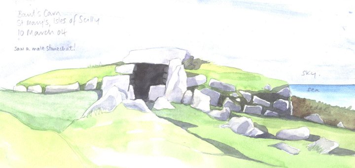
| ...let's have something decent and military!' - Graham Chapman, Monty Python's Flying Circus ...like A Long March round St Mary's, perhaps? We flew in from Land's End airfield and after 15 minutes sitting directly behind the pilot of the eight-seater 'Islander', we landed on St Mary's, the largest of the Scilly Isles. We had six hours to see as much as we could. We had planned to hire bikes to save time and my whinging at having to walk. However plans were scuppered due to it being out of season and the cycle hire shop being closed. The bus driver, sensing my panic, took pity and drove us up towards our first stop, Bant's Carn, thereby reducing the hike (and saving time) by two miles. Clearly signposted down a palm-fringed, sandy track (it really WAS palm-fringed!) we walked down past fields of narcissus which scented the air, towards Bant's Carn at the north west of the island. Bant's Carn — Fieldnotes14.03.04ceMy first Scillonian chambered cairn - and what a place to start! Much restored, this lovely kerbed, stepped cairn nestles into a wall, facing east at the northern end of the island, overlooking Tresco. The four capstones are all exposed and the chamber is about 5 metres in length. There are a lot of stones lying about which were once part of it, but never properly replaced after its early 20th century excavation and rebuild. Nevertheless, this is a real beauty and very evocative. I sat and marvelled at it in the sparkling light and found myself, Francis of Assisi-like - surrounded by birds: song thrushes, mistle thrushes and to my sheer delight, a male stonechat swooped and sang. Bant's Carn — Images14.03.04ce
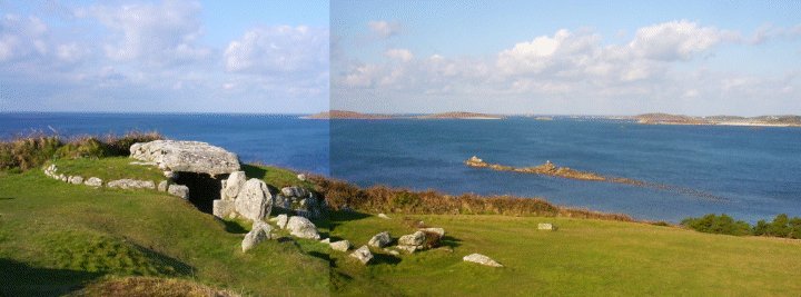
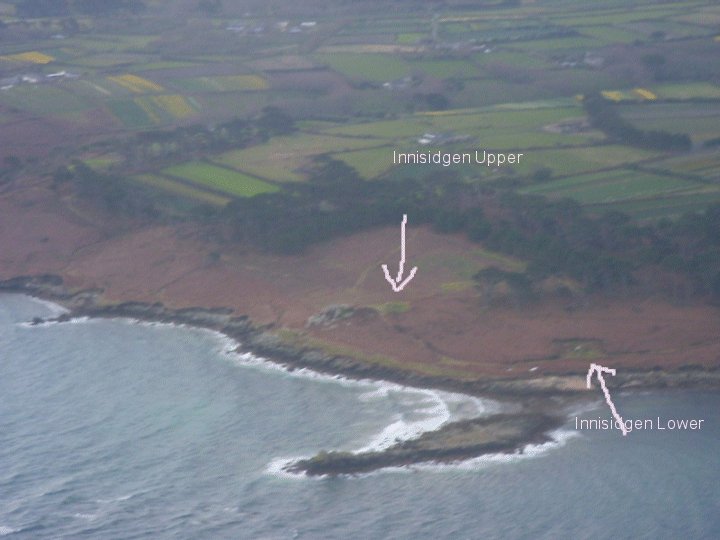
Innisidgen — Fieldnotes17.03.04ceA glorious cairn with a long chamber - about 4 and half metres, with four great capstones. These are only just breaking through the top grassy covering of the cairn giving the appearance of exposed ribs. Its kerbstones keep it from flopping, so it still looks pert and strong. Not only is the cairn itself heart-stoppingly perfect, it's location is breathtaking with views over turquoise seas facing east to St Martin's and the scatter of the Eastern Isles. By heck, this place is lovely! Innisidgen — Images17.03.04ce
Innisidgen Lower — Fieldnotes17.03.04ceDown the slope a bit and closer to the sea than Innsidgen Upper, this cairn has mostly lost its kerbstones. Its chamber is now open at both ends and has only two capstones left which are completely exposed: its a lot more ruined than its sister, Innsidgen Upper. But it is charming - covered and surrounded by a well-manicured soft carpet of closely cropped heathers and moss, giving it the appearance of a pom-pom. Innisidgen Lower — Images17.03.04ce
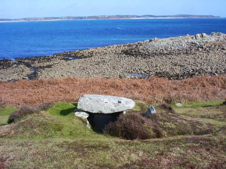
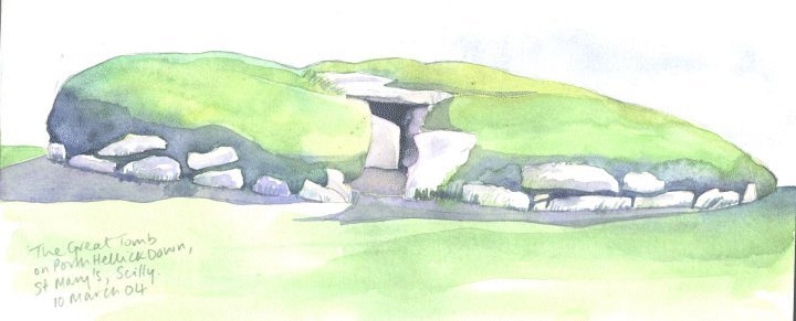
So far, we had seen nobody else on the path. Finally we reached Deep Point and as Moth whizzed around spotting all kinds of ruins I was content with standing admiring the one and saying 'hello' to a dogwalker. Other people at last! Normandy Down — Fieldnotes14.03.04ceOn the eastern edge of St Mary's, walking south between Innisidgen and Porth Hellick Downs the path passes over Gap Point towards Deep Point where Moth and I spotted five further chambered cairns in varying stages of ruin, peeping out from the carpet of heathers, gorse and moss. A gratifyingly short distance on and the reward is huge. The Great Tomb on Porth Hellick Down — Fieldnotes18.03.04ceThis massive, carefully restored cairn was given its name after excavation and renovation in 1899. It's a real platform, rising maybe a metre of an half from the level ground and is edged by kerbstones all the way round and has a diameter of around 6 or 7 metres. It has a long low chamber topped by big capstones with a tight squeeze of an entrance partly blocked by a deliberately placed slab. I was desperate to paint its soft, cushiony shape and hang out here a bit! But as it was, the wind up here was howling so I was only able to do a notated sketch whilst we munched our picnic. I was happy to get in the long chamber, not least to get out of the wind which felt colder as the sun disappeared behind the thickening clouds. Although this is probably the Scillies' main 'hollywood' site, I didn't like it here as much as the Innisidgens. The Great Tomb on Porth Hellick Down — Images13.03.04ce
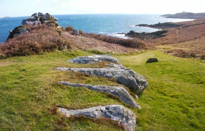
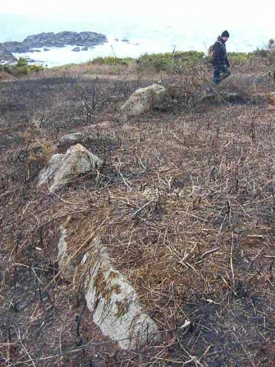
Porth Hellick Downs — Fieldnotes14.03.04ceWalk south just beyond the 'show' site, the much-restored Great Tomb on Porth Hellick Down, and you stumble across more lovely chambered cairns in various states of disrepair and size. Moth and me found another four without even trying, though it helped that the gorse and heather was not high. The cairns up here are clear to see along the ridge of the Downs from the vantage point of Salakee Downs, a few 100 metres to the west. The path takes you down towards the southern edges of the island and you turn west at last, pass a beach and rise again on the other side up onto the very gorsey, brambly Salakee Downs. We knew there were quite a few here, but the undergrowth was so dense we couldn't see as many as we'd hoped to. Salakee Down — Fieldnotes14.03.04ceAlong the southern end of St Mary's, Salakee Downs is peppered with chambered cairns, but the gorse and bramble was impenetrable at times. Fortunately for us, there had been a bit of fire which revealed some of the cairns marked on the map. We found one about 7ms in diameter with a virtually complete kerb, with maybe only two of the stones now fallen. Salakee Down — Images18.03.04ce
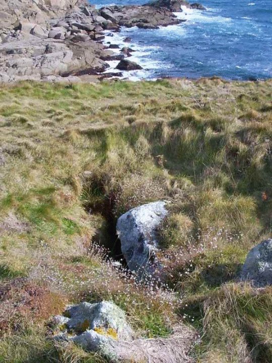
Top security! A laminated A4 sheet tied to the fence reads "Danger -do not enter!' No barbed wired, no slavvering guard-dogs. Just a simple instruction and goodwill. How charming! As was the grassy knoll and peeping stones of 'Airport cairn' which we didn't see until we'd almost passed it. Airport cairn — Fieldnotes17.03.04ceWe literally stumbled upon (or should I say INTO) this ruined cairn on the south of St Mary's as we were walking along the clifftop path that skirts the end of the runway of St Mary's airport. I had to get into it, of course, and felt around with my foot to see if there was still an open chamber underneath, and there was. Airport cairn — Images17.03.04ce
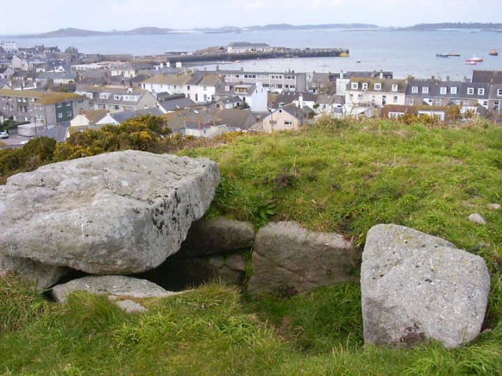
But there was a site, within Hugh Town I just HAD to see. Buzza cairn. At least a mile and half away yet. I'll spare you the emotional distress of the hike, but instead share with you my triumph at making it! Buzza Hill — Fieldnotes24.03.04ceYe gods! I was happy to finally reach Buzza as it signalled the end of The Long March. High up on a hill overlooking Hugh Town, the harbour, two beaches and pretty much 50 per cent of St Mary's, this cairn is not pretty or charming or a 'wowwing' discovery or showy. But is it here in the most commanding position of all, keeping watch. I really liked it because you can step right down into its little box chamber and be partly protected by the single remaining capstone. Very accessible if you have limited time on St Mary's. Buzza Hill — Images24.03.04ce
|
 Posted by Jane
26th March 2004ce Edited 26th September 2012ce
Jane's TMA Blog
Latest TMA Blog Posts
|
Comments (0) |
|
| You must be logged in to add a comment | |