|
|

|
Birmingham and the West Midlands: Latest Posts |
Wychbury Hill (Hillfort) — Images (click to view fullsize) |
|
 Posted by thesweetcheat
17th March 2019ce |
Wychbury Hill (Hillfort) — Miscellaneous |
|
Who put Bella in the Wych Elm? Those visiting who pass the otherwise anonymous obelisk next to the fort might notice the old graffiti "Who put Bella in the Witch Elm?" painted on the base. Rather macabrely, it relates to the discovery by four children in 1943 of the skeletonised remains of a women placed inside a tree in nearby Hagley Wood (not the hillfort, thankfully). The murder remains unsolved. https://en.m.wikipedia.org/wiki/Who_put_Bella_in_the_Wych_Elm%3F |
Posted by thesweetcheat 9th February 2019ce |
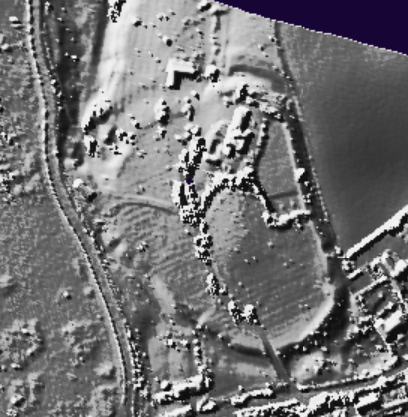
Castle Old Fort (Hillfort) — Images |
|
 Posted by juamei
25th March 2018ce |
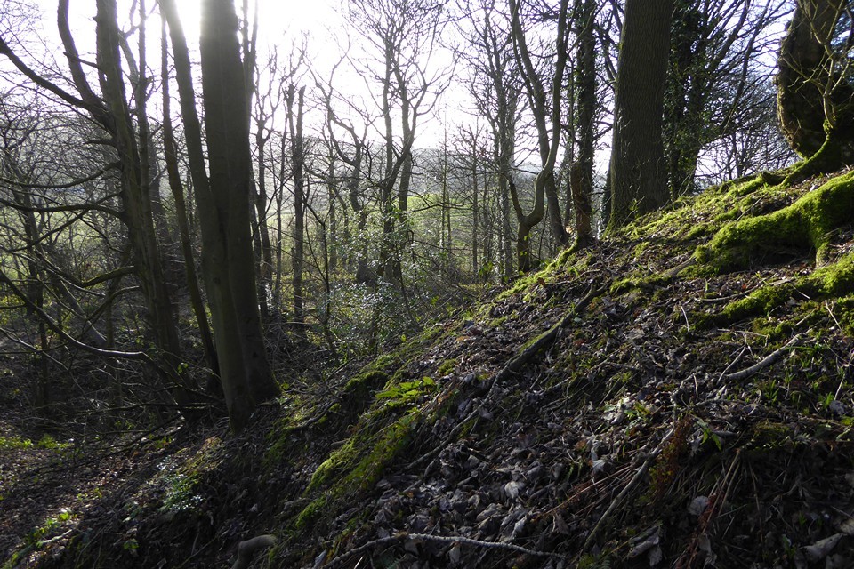
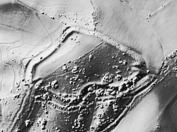
Wychbury Hill (Hillfort) — Images |
|
Posted by juamei 25th March 2018ce |
Barrowhill (Round Barrow(s)) — Miscellaneous |
|
Details of barrows on Pastscape "Barrowhill in the parish of Kings-swinford. Two uniform barrows all rock". (1) "Early Burial Mound or Low. Barrowhill east of Pensnett Churchyard. Circular. Diameter 99ft, 30ft high. Altitude 500ft". (2) No trace of these barrows was seen in perambulation of Barrow Hill, centred at SO 91608960. The hill has been extensively quarried. (3) Plot (1) refers to two barrows at Barrow Hill, whose height is below 400 feet. VCH (2) refers to one barrow, east of Pensnett churchyard, at 500 feet altitude. Eight hundred metres east of the church is Low Town at 526 feet, now fully developed with housing and instury, centred at SO 92458910. (4) It would seem that two separate sites are indicated. |
 Posted by Chance
21st July 2016ce |
Rushall Hall Barrow (Round Barrow(s)) — Miscellaneous |
|
Details of barrow on Pastscape (SP 02539992) Tumulus (NR). (1) Some years ago, a trench 22 ins deep was dug on the top of the tumulus at Rushall Hall. Many fragments of human bones together with "a few Saxon coins" were found. (2) The centre of the barrow was dug to a depth of 3ft by Mr Bird in c 1955. The bowl of an 18th century clay-pipe fragments of black glazed pottery, possibly 18th century, and an indeterminate fragment of bone were found (a). This oval mound is 16.0m E-W by 13.5m N-S and 2.2m high, with no visible ditch, and overgrown by trees and shrubs. There are slight indications of Mr Bird's digging. An engraving of 1845, in Mr Bird's possession, shows the mound lower and more bowl-shaped than the present steep-sided, conical profile. (3) No change. Published 1:1250 survey revised. (4) No change to field reports of 27 5 58 and 19 8 74. Revised 1:1250 AM survey still correct. MSD revised. (5) |
Posted by Chance 21st July 2016ce |
Catshill (Round Barrow(s)) — Miscellaneous |
|
Details of barrow on Pastscape Between Shire Oak and Frog-hall is a barrow called Catt's Hill. (1) Cat's Hill on Ogley Hay - two barrows. (2) Catshill, Cutteslowe or Catteslowe - the tumulus there was cut through when the canal was made; it was much defaced with a few scrubby oaks now upon it. The mound forms the boundary of the manors of Walsall, Ogley Hall and Little Wyrley, and stands near the foot of the western slope of Shire Oak Hill. (3) SK 05020496 - at the junction of the parish boundaries of Walsall Wood, Shire Oak and Ogley Hay there are the traces of a possible barrow. On the south-east side of a hedgerow at this point is a slight mound, c. 18.0 m. in diameter and 0.8 m. high, with no visible ditch. It is under grass. There is no trace of it on the other side of the hedgerow where it has probably been destroyed by a path. The position answers part of the descriptions given by the literary authority but it has, obviously not been cut through by the canal. No other traces of a barrow were seen along the canal or in the area. (4) SK 05150481. Mound. Site now built over but bump remains in hedge alongside canal. Mound disfigured when canal cut. (5) The S quadrant of a round barrow remains at SK 05010495 as described by F1. Surveyed at 1:1250. No traces of a barrow were found alongside the canal. At Gould's siting is a large spoil heap which would have buried any previous mound as described by Gould. (6) No change since reports of 27.5.58 and 14.8.74. (7) |
Posted by Chance 21st July 2016ce |
Castle Old Fort (Hillfort) — Miscellaneous |
|
Details of hill-fort on Pastscape [SK 0620 0330] FORT [OE] (Spearheads and Arrowheads found). (1) Castle Old Fort, Shenstone is classified as a hill-fort. It is egg-shaped in plan; its extreme inner length c.171 yds. width, 138 yds. The inner rampart is fairly complete and there was apparently an outer bank and ditch. The north-west defences have been destroyed together with the entrance that was probably here. [See AO/55/111/1 for a photo-reproduction of the plan]. (2) Two entrances on the south-east and north-west. A barbed flint arrowhead, Roman pottery and coins of Otto, Domitian, and Nero have been found here. (3) Castle Old Fort is an ovoid, univallate hill-fort occupying the south-eastern end of a ridge. The defences comprise a bank and ditch with counterscarp bank. They have been destroyed by quarrying at the north-western quadrant and mutilated elsewhere by carriage drives and ornamental gardening to the house which now occupies the interior. No trace of any entrances was seen. No further information on the 17th c. finds was gained. A 25" survey has been made. (4) No change - survey of 1958 correct. (5) No change since reports of 21.4.58 and 9.9.74. (6) Listed by Challis and Harding as a univallate hillfort, of 3.5 acres, now mutilated and destroyed. (7) SK 062 033. Castle Ring Old Fort. Listed in gazetteer as a univallate hillfort covering 1.5ha. (8) The hillfort, centred at SK 0620 0330, was surveyed at 1:1000 by RCHME in 1988. Much of the original defences of the hillfort of Castle Old Fort survive (as described by Authority 4), but are in poor condition. The main ditch is traceable around the entire circuit with the exception of the NW and SE corners of the fort where extensive quarrying has virtually destroyed the ramparts. An outer bank is visible in places, but this is quite diffuse - to the north it has clearly been over-ploughed with narrow ridge and furrow. It is possible that a broad external bank to the SW of the fort is not directly associated with the ramparts and may instead represent a cultivation headland. Narrow ridge and furrow also covers much of the fort interior on an east-west orientation, and this has affected the preservation of the inner rampart. Down the west side the ridge and furrow appear to overlie the inner rampart, whilst at the east the inner scarp has been sharpened by ploughing; a low bank toward the southern end is probably associated with later cultivation rather than with the original defences. The fort has internal measurements of 170m north to south and 130m transversely. The remains of a simple in-turned entrance are visible in the rampart in the SE of the fort. This entrance remained in use until the construction of The Castle Fort house, at which time the gap was closed. A second blocked gap is discernable in the SW rampart; this appears to have been in use until at least 1923 (9a). A former track way associated with the SE entrance is still discernable as a narrow terrace extending from the breach in the rampart in a NW direction for a distance of around 90m. No evidence of a former entrance in the NW of the fort was found, and a breach in the centre of the N rampart does not appear to be original. Numerous track ways now dissect the fort interior, principally a means of access to a reconstructed house within the fort (SK 00 SE 12). Full RCHME survey information, including a detailed report, is available in the NMR Archive. (9) |
Posted by Chance 21st July 2016ce |
Aldridge Mound (Artificial Mound) — Miscellaneous |
|
Details of mound on Pastscape At the back of Aldridge church is a small tumulus. (1) A mound north of Aldridge church is supposed to be the burial place of a chief. (2) SK 06140101 - this mound is shown but not described on OS 6", 1913-38. It is 28.0 m. in average diameter and 2.2 m. high with traces of a ditch on the east and west. It has been mutilated by quarrying. It falls on high ground on the northern crest of an east-west ridge, at the edge of a playing-field. It is accepted locally as a barrow and is probably the feature referred to by the 19th c. literary references. Certain identification of the mound as a barrow is not possible in its present condition. (3) Mound situated in field known as Windmill Flat suggesting it is a mill mound. (4) Surveyed at 1/2500. (5) No change since reports of 8.10.58 and 16.8.74. 1:2500 survey still correct. (6) Windmill field appears in undated extracts from medieval court rolls compiled for a 17th century brief. (7a) Many other 17th century references to Windmill field in deeds etc. (7) |
Posted by Chance 21st July 2016ce |
Wychbury Hill (Hillfort) — Miscellaneous |
|
Details of hill-fort on Pastscape (SO 91908180) Wychbury Hill (TI) Camp (NR). Wychbury Camp is a contour, multi-vallate hill-fort with complex defences enclosing 7 1/4 acres and an annexe of 5 1/2 acres on the south. The entrances on the north-east and south-west sides of the fort are formed by incurved ramparts, the latter being approached by a wide track bounded by ditches. An excavation by E B Marten in 1884 produced two small bronze rings, since lost, but one of which was identified as an Early Iron Age terret by the British Museum. Several Roman coins in adjacent fields may indicate Romano-British occupation. (Coin hoard also found nearby-see SO 98 SW 5). The hill-fort has been badly damaged by tracks. Published survey (1:2500, 1923-4) has been revised. Iron Age field system, Wychbury Hill. Wychbury Ring, an Iron Age bivallate hillfort, measures internally 250.0m east-west by 150.0m transversely. The inner rampart is from 16.0m to 20.0m in width and up to 2.6m in height internally. It drops 6.0 to 8.0m to the foot of the inner ditch which is up to 10.0m in width and 1.7m in depth. The outer rampart is best preserved on the south side where it is 10.0m in width and rises from 2.0 to 3.0m from the outer ditch. The latter averages 10.0m in width and is up to 1.2m in depth. On the north side the inner ditch is silted up and the outer bank reduced to a lynchet-like slope. There are no traces of the outer ditch on the north west and north sides. The ramparts are boldly inturned at the entrances of the east and south west. The track with ditches leading to the latter entrance, referred to by Cantrill(2), is modern. The 'annexe', also referred to by Cantrill, is non-existent. An old hollow-way, some 2.0m deep, 80.0m south of the hillfort, has been mistaken for outworks. A perambulation of the arable slopes below wooded Wychbury Hill produced no traces of an Iron Age field system. Several fields on the north east and south east sides contain traces of rig and furrow and in one field in particular, centred at SO 92158197, it is better preserved than elsewhere and the baulks, separating areas of rig running in differing directions, might have been mistaken for an Iron Age system when viewed from the hill-fort. (Aston (5)) Published 1:2500 survey 1969 revised. |
Posted by Chance 21st July 2016ce |